
Geiranger hiking routes – Things to do
Whether you are visiting Geiranger for a few hours or several days, there are ample opportunities for things to do in Geiranger, especially hiking. At the map, you will find an overview of some of the hiking trails around Geiranger, especially suited for the summer period (late May to the end of September). Trail accessibility largely depends on weather and snow conditions, so it is always a good idea to check the accessibility before your hiking tour. Feel free to contact us for more information about the trails (post@verdsarvfjord.no) . Weather and other conditions can vary a lot throughout the year, and in periods the risk of rock falls, and avalanches can mean that certain trails should be avoided. Show respect for the forces of nature. We are happy to advise you on safe hiking choices.
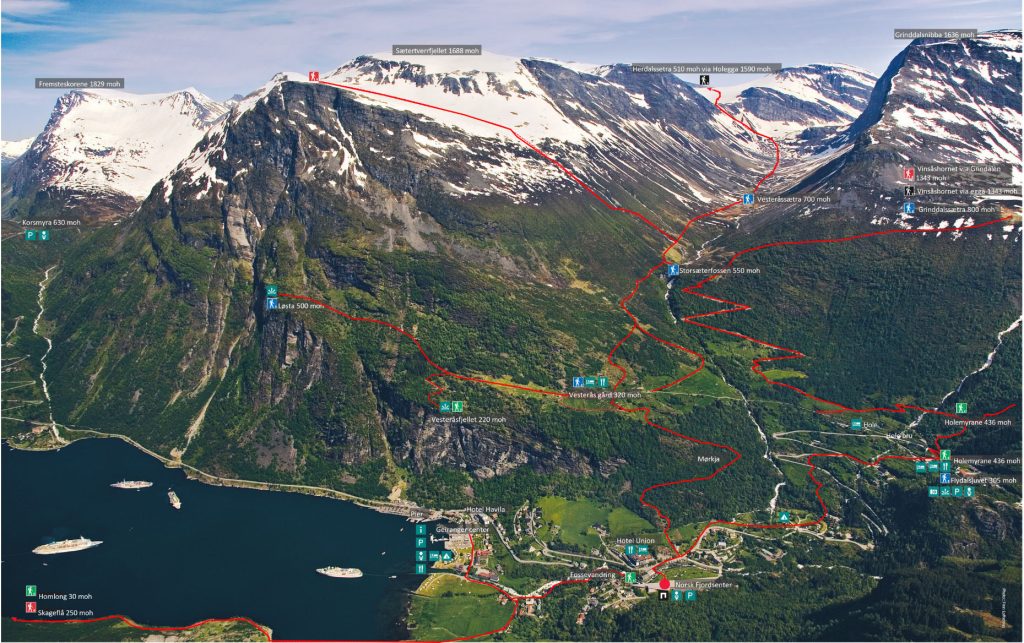
Geiranger hiking map
Each trail is marked by difficulty level: Green for easy, Blue for medium, Red for demanding, and Black for expert hikers.

Waterfall Hike (Fossevandring)
One of the few trails accessible year-round is the Waterfall Hike (Fossevandring on the map). Starting from the pier in Geiranger, the scenic route leads to the Norsk Fjordsenter, UNESCO’s World Heritage Visitor Centre. The hike covers a distance of 1,2 km, with the final 400 meters featuring 327 stair steps with handrails, offering safety and support as you take the trail. By the end of the trail, you’ll have ascended 85 meters in elevation, and the entire walk typically takes about 40 minutes from the village center to the Norsk Fjordsenter.
This trail offers a different experience with each season. In winter, the Geiranger River and Storfossen waterfall are often nearly frozen, creating a magical scene of giant ice formations and towering icicles. During the summer, however, the river surges with power, its spray filling the air with a refreshing mist. Even on sunny days, you may find yourself delightfully drenched by the waterfall’s force.
This family-friendly trail is designated as an easy, green route. For those looking to learn more about the area’s geology, local stories, and life along the fjord, the World Heritage Visitor Center offers guided tours along the Waterfall Trail, led by a Fjord Ranger (read about it here). This tour is an excellent option for those interested in the unique landscapes of Geiranger and the rich cultural history of the fjords.

Photo: Hyke Studio. Waterfall Hike together with a Fjord Ranger.
The Waterfall walk (Fossevandring) is part of a larger trail called Fosseråsa which extends all the way to the Stosæterfossen waterfall, 550 meters above the sea level. From the Norsk Fjordsenter to Storseterfossen, the trail is marked as a blue route, indicating medium difficulty. This extension offers a more challenging hike and rewards you with incredible views.
Please note that during winter, parts of the Fosseråsa Trail may be inaccessible due to weather conditions, so it’s important to check before planning your hike.
Whichever tour you choose, always take necessary safety precautions:
- You hike at your own risk
- In case of accidents call 113 or 112.
- Report your destination and walk in a group if possible.
- Stay on the marked trails if you are an inexperienced hiker.
- Proceed with caution along riverbanks, high cliffs and in difficult terrain
- Always bring a map on longer hikes.
Enjoy your stay in Geiranger and have safe hiking tours.